Sortieren nach:
- Kategorie
- Liste
- Galerie
-
16 Los(e)/Seite
Ein Abonnement der Preisliste ist notwendig um Ergebnisse, von Auktionen die vor einem längeren Zeitraum als 10 Tagen stattgefunden haben, ansehen zu können. Klicken Sie hier für mehr Informationen

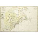
BONNE (RIGOBERT) Atlas de toutes les parties connues du globe terrestre, John Cary, 1793 (2)
[BONNE (RIGOBERT)]Atlas de toutes les parties connues du globe terrestre, half-title, 22pp. of text (including hand-coloured title), 50 hand-colo...
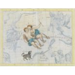
CELESTIAL MAPS MYNDE (JAMES), AFTER JOHN FLAMSTEED. Collection of four celestial maps, from Atlas...
CELESTIAL MAPSMYNDE (JAMES), AFTER JOHN FLAMSTEED. Collection of four celestial maps, from Atlas Coelestis, hand-coloured engraved maps, 532 x 64...
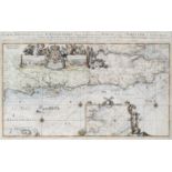
CORNWALL HOOGHE (ROMEYN DE) Carte maritime de l'Angleterre depuis les Sorlingues jusques à Portla...
CORNWALLHOOGHE (ROMEYN DE) Carte maritime de l'Angleterre depuis les Sorlingues jusques à Portland, hand-coloured engraved chart on two sheets jo...
![DENMARK JANSONNIUS (JOANNES) Daniae regni typum, [Amsterdam], 1629; and another (2)](https://portal-images.azureedge.net/auctions-2020/bonham10121/images/26ceae1b-bd83-4c87-8549-ac080158a4e0.jpg?w=155&h=155)
DENMARKJANSONNIUS (JOANNES) Daniae regni typum, hand-coloured double-page engraved map, wide borders on each side, incorporating 8 city views (in...
![FRANCE - BRITTANY [WAGHENAER (LUCAS JANSZOON)] De Zee Custe, met de Eijlande van Bretaignen, tuss...](https://portal-images.azureedge.net/auctions-2020/bonham10121/images/18bd1274-1b40-4a60-abd4-ac080158ab80.jpg?w=155&h=155)
FRANCE - BRITTANY [WAGHENAER (LUCAS JANSZOON)] De Zee Custe, met de Eijlande van Bretaignen, tuss...
FRANCE - BRITTANY[WAGHENAER (LUCAS JANSZOON)] De Zee Custe, met de Eijlande van Bretaignen, tusschenn Blauet en Picqueliers, double-page engraved...
GREENWOOD (CHARLES AND JOHN) Atlas of the Counties of England, from Actual Surveys Made from the ...
GREENWOOD (CHARLES AND JOHN)Atlas of the Counties of England, from Actual Surveys Made from the Years 1817 to 1833, engraved title with hand-colo...
JAILLOT (ALEXIS HUBERT) Atlas nouveau contenant toutes les parties du monde, ou sont exactement r...
JAILLOT (ALEXIS HUBERT)Atlas nouveau contenant toutes les parties du monde, ou sont exactement remarqués les empires, monarchies, royaumes, estats...
![LONDON UNDERGROUND GARBUTT (PAUL E.) London Transport... Underground, Waterlow & Sons, [c.1975]](https://portal-images.azureedge.net/auctions-2020/bonham10121/images/ae67c03a-41d7-4337-84d3-ac080158bf57.jpg?w=155&h=155)
LONDON UNDERGROUND GARBUTT (PAUL E.) London Transport... Underground, Waterlow & Sons, [c.1975]
LONDON UNDERGROUNDGARBUTT (PAUL E.) London Transport... Underground, large colour printed map, mounted on fibreglass panel, mounting holes drille...
![NORFOLK [WAGHENAER (LUCAS JANSZOON)] The sea mappe of the north coaste of England betweene Walbe...](https://portal-images.azureedge.net/auctions-2020/bonham10121/images/1e950272-a245-4d0d-9878-ac0d010a41e4.jpg?w=155&h=155)
NORFOLK [WAGHENAER (LUCAS JANSZOON)] The sea mappe of the north coaste of England betweene Walbe...
NORFOLK[WAGHENAER (LUCAS JANSZOON)] The sea mappe of the north coaste of England betweene Walberswick & Burnham with all the bankes and sholdes th...
![SOUTH AMERICA - STRAIT OF MAGELLAN [DUDLEY (ROBERT)] Carta particolare dello Stretto di Magellan...](https://portal-images.azureedge.net/auctions-2020/bonham10121/images/d6af6606-f05b-46a0-a482-ac080158c5e1.jpg?w=155&h=155)
SOUTH AMERICA - STRAIT OF MAGELLAN [DUDLEY (ROBERT)] Carta particolare dello Stretto di Magellan...
SOUTH AMERICA - STRAIT OF MAGELLAN[DUDLEY (ROBERT)] Carta particolare dello Stretto di Magellano e di Maire, early issue without 'Lo.6o' added t...
![SOUTH AMERICA - STRAIT OF MAGELLAN [JANSSONIUS (JOHANNES)] Freti Magellanici ac novi freti vulgo ...](https://portal-images.azureedge.net/auctions-2020/bonham10121/images/47e8cef1-4de2-43ec-a9b8-ac080158cc76.jpg?w=155&h=155)
SOUTH AMERICA - STRAIT OF MAGELLAN [JANSSONIUS (JOHANNES)] Freti Magellanici ac novi freti vulgo ...
SOUTH AMERICA - STRAIT OF MAGELLAN[JANSSONIUS (JOHANNES)] Freti Magellanici ac novi freti vulgo Le Maire exactissima delineatio, sea creatures, d...
SOUTH COAST AND THAMES ESTUARY HOOGHE (ROMEYN DE) Carte nouvelle des costes d'Angleterre depuis l...
SOUTH COAST AND THAMES ESTUARYHOOGHE (ROMEYN DE) Carte nouvelle des costes d'Angleterre depuis la riviére de la Tamise jusques à Portland, & des I...
STRABO Strabonis rerum geographicarum libri XVII, FIRST EDITION, Geneva, Eustathius Vignon, 1587
STRABOStrabonis rerum geographicarum libri XVII, FIRST EDITION, edited by Isaac Casaubon, title within woodcut historiated border, Latin and Gree...
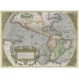
WORLD AND CONTINENTS ORTELIUS (ABRAHAM) Typus orbis terrarum... 1587; Americae sive novi orbis, n...
WORLD AND CONTINENTSORTELIUS (ABRAHAM) Typus orbis terrarum... 1587; Americae sive novi orbis, nova descriptio; Asiae nova descriptio; Africae tab...
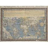
WORLD GILL (MACDONALD) The 'Time and Tide' Map of the Atlantic Charter, George Philip & Son, for ...
WORLDGILL (MACDONALD) The 'Time and Tide' Map of the Atlantic Charter, large colour lithographed decorative map, laid on linen, slightly frayed a...

DU MAURIER (DAPHNE)Rebecca, FIRST EDITION, light spotting, publisher's cloth, dust-jacket, spine panel toned and with small loss at head and foot...
-
16 Los(e)/Seite