


RUSSLAND : „Russiae vulgo Mocscovia dictae Partes Septentrionalis et Orientalis“. Grenzkolorierte Kupferstichkarte mit Titel-, Wappen- und allegor...
Sammlerobjekte Auktionen
Beliebte Kategorien
Antike Landkarten
Musikinstrumente & Memorabilia
Banknoten & Wertpapiere
Sport Memorabilia & Ausrüstungen
Briefmarken
Schreibgeräte
Kameras & Fotoausrüstungen
Unterhaltung Memorabilia
Religiöse & Sakrale Kunst
Wissenschaftliche Instrumente
Waffen, Rüstungen & Militaria
Wein & Spirituosen
Präparate & Naturkundliches
Küchenutensilien
Werkzeug
Eisenbahngeschichte
Ausgewählte Auktionen
Kommende Auktionen

205 Los(e)
Sortieren nach:
- Kategorie
- Liste
- Galerie
-
205 Los(e)/Seite

RUSSLAND : „Generalis Totius Imperii Russorum...“. Teilkolorierte Kupferstichkarte mit figürlicher Eckkartusche, Legende und Meilenanzeiger von J....

Los 5
UKRAINE : „Amplissima Ucraniae Regio, Palatinatus Kioviensem et Bractlaviensem complectens...“.
UKRAINE : „Amplissima Ucraniae Regio, Palatinatus Kioviensem et Bractlaviensem complectens...“. Teilkolorierte Kupferstichkarte mit allegorischer ...

Los 7
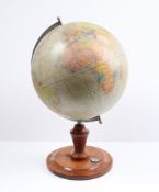
Table Globe
Table Globe, paper printed and described in German on original ebonized stand around 1900. 40 cm high.

Los 9
Columbus Globe
Columbus Globe, paper with colour printed card, on metal base. Berlin around 1960.

Measures approx. 36 x 22 inches, foxing and yelling on edges

A rare John Miller 3-inch pocket globe, Scottish, published 1793,cartouche printed A NEW GLOBE of the Earth By John Miller Mathematical Instrument...

A 2 ¾-inch terrestrial pocket globe after Herman Moll, English, circa 1775,the rectangular cartouche inscribed A Correct Globe With The New Disco...

Los 30
ANSON, GEORGE, BARON. 1697-1762. A Voyage Around the World, in the Years MDCCXL, I, II, III, IV....
ANSON, GEORGE, BARON. 1697-1762. A Voyage Around the World, in the Years MDCCXL, I, II, III, IV. London: For the author, 1749. 4to (245 x 196 mm)...

Los 36
Middle East.- Fraser (James) The History of Nadir Shah, formerly called Thamas Kuli Khan, second ...
Middle East.- Fraser (James) The History of Nadir Shah, formerly called Thamas Kuli Khan, second edition, engraved frontispiece, folding engraved ...
![POCKET GLOBE; FOREST, J. [Globe Terrestre.] Paris: Forest, Géographe-Éditeur, 17 Rue d...](https://portal-images.azureedge.net/auctions-2024/bonham10894/images/1d4d34d2-06f7-4c2c-a840-b15300783efc.jpg?h=175)
POCKET GLOBE; FOREST, J. [Globe Terrestre.] Paris: Forest, Géographe-Éditeur, 17 Rue de Buci, c.1930. A 3 inch (7.7 cm) diameter pocket globe off...
![Hungary.- Speed (John) The Mape of Hungari..., engraved map, 1626 [but c.1676]](https://portal-images.azureedge.net/auctions-2024/forum-10418/images/5bef1aa6-8f11-4f28-9b94-b15400e43335.jpg?h=175)
Hungary.- Speed (John) The Mape of Hungari..., carte-a-figure map, eight costumed figures to the vertical margins, four oval vignettes of principa...

Topography. Novus XVII Inferioris Germaniae(..) Merian. 1659. Provinciarum Typus. Caspar Merian, “Topographia Germaniae Inferioris” published by C...

Spain.- Laborde (Alexandre de) A View of Spain, 5 vol., 29 engraved maps, some folding, a few vol. with book labels, some leaves spotted or browne...

Los 67
World.- Bowdler (Thomas) Letters Written in Holland..., first edition, Printed for the Benefit of...
World.- Bowdler (Thomas) Letters Written in Holland, in the Months of September and October, 1787..., first edition, 2 folding engraved maps, titl...

Los 68
World.- Levasseur (V.) Atlas National Illustre des 86 Departements et des Possessions de la Franc...
World.- Levasseur (Victor) Atlas National Illustre des 86 Departements et des Possessions de la France Divise par Arrondissements, Cantons et Comm...
Erdglobus.Herausgegeben von Kartogr. Institut der Verlagshandlung von Dietrich Reimer. (Andrews u. Steiner) 1943, Masstab 1:38.000 000. Holzbodenp...

Los 70
Britain.- Camden (William) Viri Clarissimi Britannia, sive florentiss Regnorum Angliæ, Scotiæ, Hi...
Britain.- Camden (William) Viri Clarissimi Britannia, sive florentiss Regnorum Angliæ, Scotiæ, Hiberniæ ..., title with woodcut device, 18 folding...

Britain.- Cary (John) Cary's New and Correct English Atlas, engraved title, engraved dedication, 47 engraved maps hand-coloured in outline, tissue...

Los 74
Britain.- Railways Handkerchief (1850s) The Railways in Great Britain, Also the Line of Navigatio...
Britain.- Railways Handkerchief Map (circa 1850s) The Railways in Great Britain, Also the Line of Navigation From the Principal Sea Ports to Both ...

Los 75
England.- Fuller (Thomas) The History of the Worthies of England, first edition, Printed by J.G.W...
England.- Fuller (Thomas) The History of the Worthies of England, first edition, engraved portrait frontispiece, 12pp. 18th century index at end, ...
![Ireland.- Taylor (Alexander) A New Map of Ireland..., [c.1790s].](https://portal-images.azureedge.net/auctions-2024/forum-10418/images/ec86e9e5-e7a2-4639-ae48-b15400e481d6.jpg?h=175)
Ireland.- Taylor (Alexander) A New Map of Ireland..., engraved map with original hand-colouring, sheet 738 x 623 mm., dissected and mounted on lin...

Los 81
Kent.- Speed (John) Kent with her Cities and Earles described and observed, engraved map, 1676
Kent.- Speed (John) Kent with her Cities and Earles described and observed, county map with inset plans of Rochester and Canterbury, engraving wit...

Los 82
Kent.- Symonson (Philip) A New Description of Kent...., the tractes of Ryuers, Rylles and creeks ...
Kent.- Symonson (Philip) A New Description of Kent...., the tractes of Ryuers, Rylles and creeks with the trendinge of the Sea-Shore be more natur...

Los 83
London.- Ogilby (John) The Road from London to Aberistwith...; The Continuation of ye Road from L...
London.- Ogilby (John) The Road from London to Aberistwith...; The Continuation of ye Road from London to Aberistwith, Plate ye Second...; The Con...

Los 84
River Thames.- Pine (John) Thamesis Descriptio Anno 1588, after Robert Adams (c.1530-1595), engra...
River Thames.- Pine (John) Thamesis Descriptio Anno 1588, after Robert Adams (c.1530-1595), engraving, from a copy drawn by Mr. Joseph Ames, 8 Apr...

Photolitho,Measures 40 x 30 inches

Los 97
Howitt (Samuel) [A New Work of Animals, Principally Designed from the Fables of Æsop, Gay, and Ph...
Howitt (Samuel) [A New Work of Animals, Principally Designed from the Fables of Æsop, Gay, and Phædrus], lacking title, but with manuscript index,...

Los 101
Vienna Artist around 1815
Vienna Artist around 1815, two views of Vienna on one paper page, monogrammed AC ? and dated 1815 and described, in passepartout, 30 x 44 cm, blac...
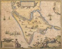
A believed 17th century hand coloured engraved map of the hypothetical continent Magellanica. The map in Spanish, marked to lower right hand corne...
Los 112
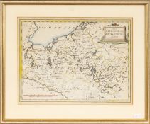
Karte Mecklenburg
Karte Mecklenburgaltcolorierte Landkarte „Das Herzogthum Mecklenburg“, Kupferstich um 1870, 22,5 x 30 cm, gerahmt
Los 113
Stadtplan La Rochelle
Stadtplan La Rochelle„Der Mächtigen und Vesten Statt Roschell wahrhafftige Abcontrafaktur“, Sebastian Munster 1544, aus Munsters Cosmographia, Ori...

P.P VAN AUBEL (actif au 20e siecle)Portrait d'une femme Encre sur papier, réalisée à la manière d'un texte.Signée en bas à droite.Inkt op papier, ...
A collection of four hand coloured Victorian engraved maps of England published by Thomas Moule (English, 1784 – 1851). The lot comprising a map o...

Los 151
Nationalsozialismus -
Nationalsozialismus - Konzentrationslager - Plan obozu Koncentracyjnego "Gusen" Austrii kolo Lincu. 1:2880. Lichtdruck. Gezeichnet v. M. Kurasniew...

Los 159
Royal Justiciar to Henry III.- Basset (Philip) Copy of a charter, granted in 1268 by Sir Henry Lo...
Royal Justiciar to Henry III.- Basset (Philip, justiciar and royalist nobleman, d. 1271) Copy of a charter, granted in 1268 by Sir Henry Longchamp...

Los 171
Kelvin & Hughes Compass
Kelvin & Hughes Compass, in metal box. Movable. 20th Century. 8 cm diameter.

Los 189
Fast against the French enemy.- Queen Anne By the Queen, a Proclamation, for a General Fast...for...
Fast against the French enemy.- Queen Anne. By the Queen, a Proclamation, for a General Fast...for disappointing the boundless ambition of France,...

Measures approx. 36 x 22 inches, foxing and yelling on edges

Los 210
Johnson (Samuel) A Dictionary of the English Language, 2 vol., fifth edition, for W. Strahan, et ...
Johnson (Samuel) A Dictionary of the English Language, 2 vol., fifth edition, titles in red and black, vol. 1 lacking all after 12Z2, initial leav...

Los 211
Alter kolorierter Kupferstich mit Darstellung des Bistums Hildesheim nebst Umland von Johann Jansso
Alter kolorierter Kupferstich mit Darstellung des Bistums Hildesheim nebst Umland von Johann Janssonius (1588 - 1664) aus dem Jahr 1647; Doppelsei...

Los 212
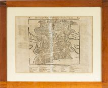
Seltener, quadratischer Kupferstich des Stadtkerns von Göttingen; Darstellung des Stadtkerns mit Wa
Seltener, quadratischer Kupferstich des Stadtkerns von Göttingen; Darstellung des Stadtkerns mit Wall, wohl im 17. Jhd.; war mehrfach gefaltet; Ra...

Los 213
Alter Merian Kupferstich von 1654 mit Darstellung der "Stad und Festung Nienburg - an der Weser"; h
Alter Merian Kupferstich von 1654 mit Darstellung der "Stad und Festung Nienburg - an der Weser"; hinter Passepartout gerahmt; Maße ca.: Bild: 21x...

Maps of France 1881 "Le Ministre De La Guerre", original case.

TANNER, HENRY S. United State of America. Philadelphia: H.S. Tanner, 1832. Engraved map, approximately 61,8 x 48,4 in, with hand-colored territor...
![CHATELAIN, HENRI. 1684-1743. Carte De La Nouvelle France.... [Amsterdam: 1719.]](https://portal-images.azureedge.net/auctions-2024/bonham10926/images/184d5f4b-af1d-466b-9196-b155000e2273.jpg?h=175)
CHATELAIN, HENRI. 1684-1743. Carte De La Nouvelle France.... [Amsterdam: 1719.] Hand-colored engraved map, 420 x 490 mm. Matted and framed. Not e...
![ORTELIUS, ABRAHAM. 1527-1598. Americae sive novi orbis, nova descriptio. [Antwerp]: Ortelius, 15...](https://portal-images.azureedge.net/auctions-2024/bonham10926/images/00394e5a-9d41-4bca-a34e-b155000e2071.jpg?h=175)
Los 243
ORTELIUS, ABRAHAM. 1527-1598. Americae sive novi orbis, nova descriptio. [Antwerp]: Ortelius, 15...
ORTELIUS, ABRAHAM. 1527-1598. Americae sive novi orbis, nova descriptio. [Antwerp]: Ortelius, 1587 [but 1591]. Engraved map with hand-coloring, a...

Los 244
NEW ENGLAND MAP. Colton's Massachusetts, Connecticut, Rhode Island. New York: G.W. & C.B. Colton...
NEW ENGLAND MAP. Colton's Massachusetts, Connecticut, Rhode Island. New York: G.W. & C.B. Colton & Co., 1879. Engraved map with hand-colored boun...
![ZATTA, ANTONIO. 1757-1797. La Pensilvania, la Nuova York, il Jersey settentrio[na]le.... Venice:...](https://portal-images.azureedge.net/auctions-2024/bonham10926/images/3505b891-d55b-4d40-a8f9-b155000e2dee.jpg?h=175)
Los 245
ZATTA, ANTONIO. 1757-1797. La Pensilvania, la Nuova York, il Jersey settentrio[na]le.... Venice:...
ZATTA, ANTONIO. 1757-1797. La Pensilvania, la Nuova York, il Jersey settentrio[na]le.... Venice: Antonio Zatta, 1778. Hand-colored engraved map, ...

Los 247
CONNECTICUT AREA MAPS. A group of two maps of Farmington and Plainville, from Atlas of Hartford ...
CONNECTICUT AREA MAPS. A group of two maps of Farmington and Plainville, from Atlas of Hartford and Tolland Counties, Connecticut, F.W. Beers, 186...

El Lissitzky (1890-1941) – Graphic, contructivist composition, described on the bottom, on paper, in passepartout, 22 x 25 cm

Juvenilia.- A Present for A Little Girl, engraved hand-coloured vignette on title, 27 brightly hand-coloured wood-engraved illustrations (3 full-p...

Los 273
Albert Einstein Photo Print
Albert Einstein, born on March 14, 1879, in Ulm, in the Kingdom of Württemberg in the German Empire, was one of the most influential scientists o...

Los 280
Game.- Wallis (John) Wallis's New Game of Universal History and Chronology, engraving with hand-c...
Game.- Wallis (John) Wallis's New Game of Universal History and Chronology, spiral track with 137 portraits and scenes around a portrait of the Pr...

Topography, Groningen, publisher: J. Oomkes. Grote Markt seen to the west, with town hallView of the facade of the town hall in Groningen, 1820-18...

Topography. America, South America / Suriname / Guyana / French Guyana / Brazil / El Dorado; Janssonius / Hondius - Guiana sive Amazonum region - ...

Los 422
Karte v. Hersfeld
Karte v. Hersfeld18.Jh.Teilkolor. Kupferstich, ersch. bei Valk & Schenk Amsterdam. Mittelfalz. Leicht nachgedunkelt/berieben/fleckig, leichte ...

Jan VAN CAMPENHOUT (1907-1972) 'City view by Night'Dimensions: (W:60 x H:70 cm)

Los 485
Asien - Indonesien -
Asien - Indonesien - Molluken. "Moluccae Insulae celeberrimae". Mit altem Grenz- und Flächenkolorit, Kupferstichkarte, G. Blaeu in Amsterdam, um 1...

Australien und Ozeanien - Sotzmann, Daniel Friedrich. Karte des Grossen Oceans gewöhnlich Das Süd Meer genannt, nebst allen neuen Entdeckungen in ...