Refine your search
Filtered by:
- Sale Section,
- Category
- List
- Grid
-
11 item(s)/page
A subscription to the Price Guide is required to view results for auctions ten days or older. Click here for more information
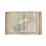
![[Chart of the Indian Ocean] Bellin, Jacques Nicolas Carte Reduite de l'Ocean-Oriental ou Mers des In](https://portal-images.azureedge.net/auctions-2021/srly10340/images/552cdcf6-2770-48d9-82f6-ad9b00ab2ab7.jpg?w=155&h=155)

[Chart of the Indian Ocean] Bellin, Jacques Nicolas Carte Reduite de l'Ocean-Oriental ou Mers des In
1740, 89 x 63.5cm, delicately hand-coloured ...[more]
![[Map of Africa] De Lisle, Guillaume L'Afrique Dressée par les Observations de Mrs de l'Acadamie Roya](https://portal-images.azureedge.net/auctions-2021/srly10340/images/60c9d556-aebf-4e86-9214-adaa0109a661.jpg?w=155&h=155)
[Map of Africa] De Lisle, Guillaume L'Afrique Dressée par les Observations de Mrs de l'Acadamie Roya
Amsterdam: Pierre Schenk, 1708. 66.5 x 52.5cm, hand-coloured, some marginal browning ...[more]
![[Map of Africa] Münster, Sebastian Totius Africae tabula & descriptio universalis](https://portal-images.azureedge.net/auctions-2021/srly10340/images/cf82382c-e1c7-4dac-84dc-ad9b00ab825f.jpg?w=155&h=155)
[Basel: H. Petri, 1559] 38 x 29.5cm, engraved map, slightly trimmed along upper edge, a little repaired worming with loss to one letter in title ...
![[Map of Africa] Ortelius, Abraham Africae Tabula Nova](https://portal-images.azureedge.net/auctions-2021/srly10340/images/1e32543b-4759-451c-a8a9-ad9b00ab8874.jpg?w=155&h=155)
[Antwerp: C. Plantin, c.1570], engraved map, 54 x 40cm, hand-coloured, a little trimmed ...[more]
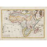
![[Map of Africa] Sandrart, Jacob von Accuratissima Totius Africae](https://portal-images.azureedge.net/auctions-2021/srly10340/images/972c00b6-bb20-408c-b6ef-adaa0109a094.jpg?w=155&h=155)
Accuratissima Totius Africae Tabula, Nuremberg, [1675], engraved map, 60 x 52cm, hand-coloured ...[more]
Africae Tabula Nova, Basel, c.1588, 40.5 x 33cm, some repairs and light dampstaining; Ruscelli, Girolamo Africa Nuova Tavola, later impression, 30...
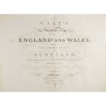
with a Considerable Portion of Scotland. London: G. and J. Cary, 1832. Large folio, 66 (of 67?) hand-coloured maps, contemporary black half morocc...
Covens, Jean and Corneille Mortier Carte très commode aux Gens de Guerre, Ingenieurs et Canonniers
Amsterdam, [c.1720], 70 x 51.5cm, framed and glazed ...[more]
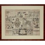
Physikalischer Atlas. Gotha: von Justus Perthes, 1845-48. 2 volumes in one, folio, 92 (of ?93) hand-coloured engraved maps or tables, comprising M...
Orbis Veteribus Notus. London: C. Smith, 1809, hand-coloured, 50.5 x 39.5cm; Cary, John A New Map of South America. London, 1828, hand-coloured, 6...
Philadelphia: J. Crissy, [c. 1820]. 8vo, engraved title, 10 double-page engraved maps, hand-coloured in outline, later cloth, offsetting to maps, ...
-
11 item(s)/page