Featured lot


Räths Welthandels-Weltverkehrsglobus, Paul Räth (1881-1929), large paper globe with countries, continents and trade roots, descriptions, colour pr...
Discover and bid on an impressive mix of collectibles for sale in live and timed online auctions at LOT-TISSIMO.

Räths Welthandels-Weltverkehrsglobus, Paul Räth (1881-1929), large paper globe with countries, continents and trade roots, descriptions, colour pr...
Handcol. engr., 47 x 57 cm, depicting an armillary sphere, a celestial globe and a terrestrial globe, Nuremburg, J.B. Homann, ca. 1720, framed und...
Du déjeuner Pullman au diner. Paris-Bruxelles-Amsterdam. Paris, Hachard & Cie, 1927. 106 x 75 cm. Corners and minor dam. to folds, professionally ...
Map (copper engraving) Africa By H. Moll Geographer Certificate of Authenticity 1744According to Wikipedia, Herman Moll was a British engraver, ca...
Map copper engraving Benjamin Baker, Germany around 1740 - Holy Roman Empire of the German NationOld map of Germany by B. Baker, c. 1740 - Holy Ro...
Old map engravings of Africa by Thomas Jefferys, around 1749Thomas Jefferys (also: T. Jefferies, Jeffery, Jeffereys, Jeffreys or Gefferys; * aroun...
Map copper engraving by John Rapkin Victoria or Port Phillip Australia, around 1850 Map of Victoria or Port Phillip Australia with decorative bord...
Map of the Mozambique Channel with Madagascar and Africa's coasts, copperplate engraving from around 1870 by Rigobert BonneCarte du Canal de Mosam...
Map "Australia with the British Settlements", around 1835Copper engraving of a detailed map of Australia with inset maps of Swan River, New South ...
A WWII Second World War British ' escape ' silk map of Eastern Europe & Greece sheets 43 H and G. Scale 1;100,000. Folds to pocket handkerchief si...
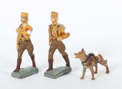
2 SA Soldaten mit HundLineol und Elastolin, 7,5-cm-Serie, SA, Lineol Fahnenträger ohne Fahne; Lineol Maschierer; Elastolin Sanitäts-Hund; min. Al...
This group of five antique engraved maps includes one color engraving in French of the Known World (Mappe-Monde ou Carte Generale de toutes les Pa...
Columbus Globe, around 1930. Paper ball with colour printed political card on wooden base with compass. 40 cm high.
Adler Globe, paper ball with printed political card around 1940, German. Wooden base with compass. 55 cm high.
Schleswig Holstein. Nordfriesland. Original kolorierte Kupferstichkarte von Joh. Mejer aus C. Danckwerth, Newe Landesbeschreibung ..., 1652. 2 Kar...
Dr. Sandro Limbach Globe, paper ball with printed coloured card with political world, around 1940. On wooden base. 50 cm high, 35 cm diameter.
Kosmos Globe, paper ball with collour printed cards , poltical around 1940 with ship lines, on wooden base , compass , 55 cm high, 35 cm diameter
Columbus Globe , paper ball with collour printed cards , political around 1941, on wooden stand , demages, compass, 50 cm high, Diamter 32 cm
Schotte Globe, Paper ball with printed colloured cards , geographic, demages, on ebonised wooden stand,Berlin around 1900, 40 cm high, diamter 16...
Räths Globe, paper ball with printed colour cards , political , around 1940 on wooden stand with compass , damages. 55 cm high 30 cm diameter
Wagner und Debes Globe, paper ball with printed colour cards on wooden stand with compass , damages, around 1930. 53 cm high 30 cm diameter
Columbus Globe , paper ball with printed colour cards, around 1950. 45 cm high diameter 33 cm
A color map depicting the land and sea area of the Sombrero Key to the Sand Key. Publishing stamp by "The U.S Coast and Geodetic Survey" located o...
Depicts a colored map of land and waterways from East Cape to Mormon Key. Publishing stamp by "The U.S Coast and Geodetic Survey" located on botto...
A color map showing the land and water areas of Cape Elizabeth to Cape Cod. Publishing stamp by "The U.S Coast and Geodetic Survey" located on bot...
A collection of x4 WWII Second World War British War Office Ordnance Survey maps. All dated 1940 comprising Hull, Great Driffield & Bridlington, Y...
A collection of approximately x80 RAF Royal Air Force and wartime OS maps comprising x20 RAF maps from the 1939-45 period including maps of Englan...
Norwegen Karte18.Jh.Tractus Norvegiae Suecicus Praefecturam Bahusiae finitimaeque Daliae provinciae partem.- Teilkolor. Kupferstich, ersch. bei Jo...
Paar Karten der Küste von Norwegen18.Jh.Dabei: Paskaert van de Cust van Noorwegen erschienen bei Johannes van Keulen, Paskaert voor een gedeelte v...
Karte der Ostsee18.Jh.Tabula Hydrographica Maris Baltici.- Teilkolor. Kupferstich, ersch. bei Johannes Janssonius. Mittelfalz. Leicht nachgedunkel...
Ostsee Karte18.Jh.Paskaart voor een Gedeelte van de Oost Zee.- Teilkolor. Kupferstich, erschienen bei Johannes van Keulen. Mittelfalz. Leicht nach...
Karte des Skagerraks17./18.Jh.Pascaarte vant Schager-Rack vande Pater-nosters aen Kol. als mede de Sondt: oock hoe dese landen van Schagen gelegen...
Karte v. Dänemark u. Südschweden18.Jh.Nieuwe Afteekening van de Sond ant Groot.- Kupferstich, erschienen bei Gerard van Keulen. Mehrfach gefalzt. ...
Dänemark Karte18.Jh.Regni Daniae.- Grenzkolor. Kupferstich, ersch. bei Johann Baptist Homann. Mittelfalz. Leicht nachgedunkelt/fleckig/wellig, lei...
Ostsee Karte18.Jh.De Oost Zee of Öster Siöön.- Teilkolor. Kupferstich, ersch. bei Gerard van Keulen. Nachgedunkelt/gebräunt/fleckig/lichtrandig, K...
Ostsee Karte18./19.Jh.Et nyt Pas=Kaart over Sundet og begge Belterne.- Teilkolor. Kupferstich, ersch. bei Christian Carl Lous. Mehrfach gefalzt. L...
David Michael Jones (1895-1974) Map of the Third Voyage wood engraving 19 x 16cm.
Reisen. Deutschlandkarte. Roost, J. B. Neue Wand – Karte von Deutschland den Königreichen Holland u. Belgien und der Schweiz, sammt den angrenzend...
Railwayana - a collection of assorted Railway maps and posters comprising; Alan Young illustrated railway map of the South West, Great Orme Tramwa...
Var. sizes. Comprises Hameleers II, 305 (17th ed., 1920), 342 (1st and 5th or 13th edition, 1919 and 1931 or 1932), 359 (5th ed., 1932), 370 (3rd ...
Amsteldam ten tweede mael vergroot (...) inden jaere 1482. Ca. 1671-1680. 26 x 31 cm. Fully backed w. thin Japan paper, otherwise very fine. Hamel...
Handcol. engr. plan, 41 x 54 cm, framed under deluxe passepartout. Hameleers I, 29, third ed., w. the address of Joan Blaeu.
Handcol. engr. plan, 15.5 x 23 cm. Hameleers I, 27, second ed. -and 4 others, all 18th cent. (total 5)
Handcol. etched plan, 27.5 x 38.5 cm. Hameleers 19, unstated ed., w. one page of Latin text and page no. 10 verso.
19th century A.D. Printed map of Egypt and Nubia with locations marked of the sketches of David Roberts, RA on his 1849 expedition; mounted in a g...
Handcol. etched plan, 34 x 48 cm, framed under deluxe passepartout. Hameleers I, 7, first ed.
Handcol. engr. plan, 47 x 56.5 cm, framed under passepartout. Hameleers I, 75, first ed., w. address of Gerard Valk in lower left corner. Rare.
Handcol. engr. plan, 42.5 x 54 cm. Fine, brightly handcol. copy. Hameleers I, 82, third ed., w. the address of F. de Wit in left margin, without t...
Handcol. engr. plan, 43 x 54 cm, framed under passepartout. Folds as publ. Hameleers I, 82, first ed.
Lithogr. plan, 15 x 18.5 cm. Hameleers II, 224, first ed. (of 3). (2) Kotting. Guide d'Amsterdam. 8me Année. (1898). Col. lithogr. plan, 43 x 34.5...
Engr. plan, 28 x 37 cm (incl. captions in Dutch and French below the image), under passepartout. In very fine, untrimmed condition. Hameleers 130,...
Handcol. engr. plan, 28 x 37 cm (incl. captions in Dutch and French below the image), under passepartout. Centre fold, but in very fine, untrimmed...
Col. lithogr. plan by A. Braakensiek, 35 x 41.5 cm, present in 3 eds. by G.L. Funke, 1872 and 1873 (2x), the first two eds. w. titles and extensiv...
Col. lithogr. plan by A. Braakensiek, 37 x 48 cm, present in 2 eds. by G.L. Funke, 1875 and 1876, w. titles and extensive text verso. Both w. fold...
Col. lithogr. plan by A. Braakensiek, 38.5 x 51 cm, present in 3 eds. by G.L. Funke, 1877, 1878 and 1879, w. titles and extensive text verso, all ...
Col. lithogr. plan, 38.5 x 51.5 cm, w. title and extensive text verso, under passepartout. W. folds (publ. as a booklet), sm. tear on fold repaire...
Engr. plan, 44 x 63.5 cm, w. the address of Frederik Willem Greebe in right margin and the name of the engraver Caspar Philips Jacobs and date 176...
Handcol. etched bird's-eye plan, 25 x 34.5 cm (excluding letterpress caption and legend), w. French text verso. Centre fold as publ., marginal fol...
4 handcol. copies and 1 uncol. copy, all 15.5 x 17.5 cm, all on complete lvs from var. editions (4x German and 1x Italian). Some browning/ foxing....
und Handels-Stadt Amsterdam. 1727. Handcol. engr. map, 49.5 x 58 cm, under passepartout. Very fine, beautifully handcol. copy. Hameleers I, 110, f...